
Aghast and somewhat ignorant at the specific extent and impact of the current Gulf of Mexico oil-spill, I took to fossicking around on the internet for answers. In this quest, I rummaged through a plethora of emotive photos (like these) until I honed in on this relatively unassuming photo of protective oil-spill booms that surround a few small islands off the coast of Louisiana.

The photo seemed to me to be eerily similar to an iconic work of art from the early 1980s whereby a couple of industrious artists created amazing large-scale sculptural installations. These bright pink installations were intended as a sort of a visual metaphor for the way in which we live between the ocean and the land. The seemingly abstract work conceptualised a very real conservation desideratum (thank you thesaurus!)
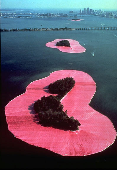
(sorry if all this is boring, my interest in buffer zones is possibly more piqued than most through my work in GIS where I mundanely buffer objects on a computer screen - to see them in the wild, so to speak, is nerdishly exciting for me)
 If all this arty rhetoric is too obscure for you, just play with this interactive oil-spill model. It maps potential spill events near Vancouver, but in general terms it helps visualise fluid movement (and the black plague of human destruction upon this fair planet)
Lastly, I don't want to overload you, but you really should check out this little Google WebApp that overlays the oil slick with a location of your choosing.
No comments:
Post a Comment